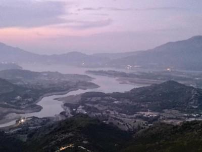
Makhniyal Second Ridge
The Makhniyal Second Ridge Trail (also called the 2nd Ridge of the Margalla Hills) is a scenic, secluded and less-traveled backcountry trekking route. It runs parallel behind the main commercial Margalla trails (Trails 1-6).
- Difficulty
- Hard
- Distance
- 12.5km
- Elevation gain
- 738 m
- Duration
- 2h
- Best season
- Oct – Apr
The journey
Makhniyal Second Ridge is a 12.5km hard out-and-back hike near Makhniyal. It climbs 738 m and takes about 2h.
The Makhniyal Second Ridge Trail (also called the 2nd Ridge of the Margalla Hills) is a scenic, secluded and less-traveled backcountry trekking route. It runs parallel behind the main commercial Margalla trails (Trails 1-6).
Trail Statistics
Trail map
Elevation profile
Climb over the length of the trail. Tap or drag along it to read elevation and grade.
Weather
Five-day forecast at the trailhead, 1,409 m.
Today
20°16°
Tomorrow
25°16°
Sun
25°16°
Mon
25°16°
Tue
25°17°
Forecast from MET Norway, updated hourly.
Frequently asked questions
Where does the Makhniyal Second Ridge trail start?
The trail is accessed along the Makhniyal–Pir Sohawa road ridge in Khyber Pakhtunkhwa.
How demanding is the track?
It is an easy-to-moderate ridge walk with rolling elevation changes and panoramic valley vistas.
Is there shade along the ridge path?
Shade is intermittent with open pine scrub, so sun protection and ample water are essential.
What wildlife should hikers stay alert for?
Wild boars, monkeys, and occasional snakes during warmer summer afternoons.
What can I see along the way?
A specific lookout point lets you view Rawal Dam and Khanpur Dam simultaneously.
Trail gallery
Trail Photos
Photos from hikers
Recent shots from the community on this trail
No community photos yet. Been here? Add the first one.
Reviews
Ratings and recent conditions from the community
No reviews yet. Hiked this trail? Be the first to share conditions and help other hikers.